The Blue Marble, a photograph of the planet Earth made on 7 December 1972 by the crew of the Apollo 17 spacecraft.
The world is the totality of entities, the whole of reality, or everything that exists. The nature of the world has been conceptualized differently in different fields. Some conceptions see the world as unique while others talk of a "plurality of worlds". Some treat the world as one simple object while others analyze the world as a complex made up of parts.
In scientific cosmology, the world or universe is commonly defined as "[t]he totality of all space and time; all that is, has been, and will be". Theories of modality talk of possible worlds as complete and consistent ways how things could have been. Phenomenology, starting from the horizon of co-given objects present in the periphery of every experience, defines the world as the biggest horizon or the "horizon of all horizons". In philosophy of mind, the world is contrasted with the mind as that which is represented by the mind. Theology conceptualizes the world in relation to God, for example, as God's creation, as identical to God or as the two being interdependent. In religions, there is a tendency to downgrade the material or sensory world in favor of a spiritual world to be sought through religious practice. A comprehensive representation of the world and our place in it, as is found in religions, is known as a worldview. Cosmogony is the field that studies the origin or creation of the world while eschatology refers to the science or doctrine of the last things or of the end of the world.
Because of the sheer complexity and enormous scope of the task, it remains to be seen whether planetary management is a feasible paradigm for maintaining global sustainability. The concept currently has defenders and critics on both sides: environmentalistDavid W. Orr questions whether such a task can be accomplished with human help and technology or without first examining the underlying human causes, while geographer Vaclav Smil acknowledges that "the idea of planetary management may seem preposterous to many, but at this time in history there is no rational alternative". (Full article...)
GCOS is a system that comprises the climate-relevant components of many contributing observing systems and networks. Its mission is to help ensure that these contributing systems, taken as a whole, provide the comprehensive information on the global climate system that is required by users, including individuals, national and international organizations, institutions and agencies. The programme promotes the sustained provision and availability of reliable physical, chemical and biological observations and data records for the total climate system - across the atmospheric, oceanic and terrestrial domains, including the hydrological cycle, the carbon cycle and the cryosphere. (Full article...)
In 1999, the Modern Library ranked Brave New World at number 5 on its list of the 100 best English-language novels of the 20th century. In 2003, Robert McCrum, writing for The Observer, included Brave New World chronologically at number 53 in "the top 100 greatest novels of all time", and the novel was listed at number 87 on The Big Read survey by the BBC. Brave New World has frequently been banned and challenged since its original publication. It has landed on the American Library Association list of top 100 banned and challenged books of the decade since the association began the list in 1990. (Full article...)
Image 4
The aircraft shown here, Chicago, led the first round the world flight in 1924. The first aerial circumnavigation of the world was completed in 1924 by four aviators from an eight-man team of the United States Army Air Service, the precursor of the United States Air Force. The 175-day journey covered over 26,345 miles (42,398 km). The team generally traveled east to west, around the northern-Pacific Rim, through to South Asia and Europe and back to the United States. Airmen Lowell H. Smith and Leslie P. Arnold, and Erik H. Nelson and John Harding Jr. made the trip in two single-engined open-cockpit Douglas World Cruisers (DWC) configured as floatplanes for most of the journey. Four more flyers in two additional DWC began the journey but their aircraft crashed or were forced down. All airmen survived. They were all awarded the Mackay Trophy aviation award for 1924. (Full article...)
Image 5
World map showing real GDP growth rates for 2009; countries in brown were in a recession.
The Great Recession was a period of marked general decline observed in national economies globally, i.e. a recession, that occurred in the late 2000s. The scale and timing of the recession varied from country to country (see map). At the time, the International Monetary Fund (IMF) concluded that it was the most severe economic and financial meltdown since the Great Depression. One result was a serious disruption of normal international relations.
The causes of the Great Recession include a combination of vulnerabilities that developed in the financial system, along with a series of triggering events that began with the bursting of the United States housing bubble in 2005–2012. When housing prices fell and homeowners began to abandon their mortgages, the value of mortgage-backed securities held by investment banks declined in 2007–2008, causing several to collapse or be bailed out in September 2008. This 2007–2008 phase was called the subprime mortgage crisis. The combination of banks unable to provide funds to businesses, and homeowners paying down debt rather than borrowing and spending, resulted in the Great Recession that began in the U.S. officially in December 2007 and lasted until June 2009, thus extending over 19 months. As with most other recessions, it appears that no known formal theoretical or empirical model was able to accurately predict the advance of this recession, except for minor signals in the sudden rise of forecast probabilities, which were still well under 50%. (Full article...)
Image 6
A free trade area is the region encompassing a trade bloc whose member countries have signed a free trade agreement (FTA). Such agreements involve cooperation between at least two countries to reduce trade barriers, import quotas and tariffs, and to increase trade of goods and services with each other. If natural persons are also free to move between the countries, in addition to a free trade agreement, it would also be considered an open border. It can be considered the second stage of economic integration.
Customs unions are a special type of free trade area. All such areas have internal arrangements which parties conclude in order to liberalize and facilitate trade among themselves. The crucial difference between customs unions and free trade areas is their approach to third parties. While a customs union requires all parties to establish and maintain identical external tariffs with regard to trade with non-parties, parties to a free trade area are not subject to this requirement. Instead, they may establish and maintain whatever tariff regime applying to imports from non-parties as deemed necessary. In a free trade area without harmonized external tariffs, to eliminate the risk of trade deflection, parties will adopt a system of preferential rules of origin. (Full article...)
Image 7
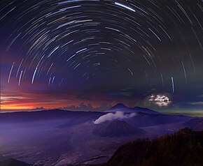
A timelapse composite panorama of different natural phenomena and environments around Mount Bromo, Indonesia.
Nature is an inherent character or constitution, particularly of the ecosphere or the universe as a whole. In this general sense nature refers to the laws, elements and phenomena of the physical world, including life. Although humans are part of nature, human activity or humans as a whole are often described as at times at odds, or outright separate and even superior to nature.
During the advent of modern scientific method in the last several centuries, nature became the passive reality, organized and moved by divine laws. With the Industrial revolution, nature increasingly became seen as the part of reality deprived from intentional intervention: it was hence considered as sacred by some traditions (Rousseau, American transcendentalism) or a mere decorum for divine providence or human history (Hegel, Marx). However, a vitalist vision of nature, closer to the pre-Socratic one, got reborn at the same time, especially after Charles Darwin. (Full article...)
Image 4The replicator in virtually all known life is deoxyribonucleic acid. DNA is far more complex than the original replicator and its replication systems are highly elaborate. (from History of Earth)
Image 5An artist's impression of the Archean, the eon after Earth's formation, featuring round stromatolites, which are early oxygen-producing forms of life from billions of years ago. After the Late Heavy Bombardment, Earth's crust had cooled, its water-rich barren surface is marked by continents and volcanoes, with the Moon still orbiting Earth half as far as it is today, appearing 2.8 times larger and producing strong tides. (from Earth)
Image 6Artist's impression of a Hadean landscape with the relatively newly formed Moon still looming closely over Earth and both bodies sustaining strong volcanism. (from History of Earth)
Image 7Earth's axial tilt causing different angles of seasonal illumination at different orbital positions around the Sun (from Earth)
Image 15A view of Earth with its global ocean and cloud cover, which dominate Earth's surface and hydrosphere; at Earth's polar regions, its hydrosphere forms larger areas of ice cover. (from Earth)
Image 17Earth's western hemisphere showing topography relative to Earth's center instead of to mean sea level, as in common topographic maps (from Earth)
Image 18Angkor Wat temple complex, Cambodia, early 12th century
Image 19Tiktaalik, a fish with limb-like fins and a predecessor of tetrapods. Reconstruction from fossils about 375 million years old. (from History of Earth)
Image 21Exaggerated illustration of Earth's elliptical orbit around the Sun, marking that the orbital extreme points (apoapsis and periapsis) are not the same as the four seasonal extreme points, the equinox and solstice (from Earth)
Image 22Artist's impression of Earth during the later Archean, the largely cooled planetary crust and water-rich barren surface, marked by volcanoes and continents, features already roundmicrobialites. The Moon, still orbiting Earth much closer than today and still dominating Earth's sky, produced strong tides. (from History of Earth)
Image 37Geologic map of North America, color-coded by age. From most recent to oldest, age is indicated by yellow, green, blue, and red. The reds and pinks indicate rock from the Archean.
Image 52A 2012 artistic impression of the early Solar System's protoplanetary disk from which Earth and other Solar System bodies were formed (from Earth)
Image 53Earth's night-side upper atmosphere appearing from the bottom as bands of afterglow illuminating the troposphere in orange with silhouettes of clouds, and the stratosphere in white and blue. Next the mesosphere (pink area) extends to the orange and faintly green line of the lowest airglow, at about one hundred kilometers at the edge of space and the lower edge of the thermosphere (invisible). Continuing with green and red bands of aurorae stretching over several hundred kilometers. (from Earth)
Image 58Artist's conception of Hadean Eon Earth, when it was much hotter and inhospitable to all forms of life. (from History of Earth)
Image 59Trilobites first appeared during the Cambrian period and were among the most widespread and diverse groups of Paleozoic organisms. (from History of Earth)
Image 64Change in average surface air temperature and drivers for that change. Human activity has caused increased temperatures, with natural forces adding some variability. (from Earth)
Image 65An animation of the changing density of productive vegetation on land (low in brown; heavy in dark green) and phytoplankton at the ocean surface (low in purple; high in yellow) (from Earth)
Image 75Pangaea was a supercontinent that existed from about 300 to 180 Ma. The outlines of the modern continents and other landmasses are indicated on this map. (from History of Earth)
Image 76Artist's impression of the enormous collision that probably formed the Moon (from History of Earth)
Chengdu is in central Sichuan. The surrounding Chengdu Plain is known as the "Country of Heaven" and the "Land of Abundance." Its prehistoric settlers included the Sanxingdui culture. The site of Dujiangyan, an ancient irrigation system, is designated as a World Heritage Site. The Jin River flows through the city. Chengdu's culture largely reflects that of its province, Sichuan; in 2011, it was recognized by UNESCO as a city of gastronomy. It is associated with the giant panda, a Chinese national symbol, which inhabits the area of Sichuan; the city is home to the Chengdu Research Base of Giant Panda Breeding. (Full article...)
Between the 7th and 11th centuries, a series of Swahili port towns developed on that area, which contributed to the development of a distinct Swahili culture and dialect. In the late medieval period, these towns were frequented by traders from Somalia, Ethiopia, Egypt, Arabia, Persia, and India. The voyage of Vasco da Gama in 1498 marked the arrival of the Portuguese, who began a gradual process of colonisation and settlement in 1505. After over four centuries of Portuguese rule, Mozambique gained independence in 1975, becoming the People's Republic of Mozambique shortly thereafter. After only two years of independence, the country descended into an intense and protracted civil war lasting from 1977 to 1992. In 1994, Mozambique held its first multiparty elections and has since remained a relatively stable presidential republic, although it still faces a low-intensity insurgency distinctively in the farthermost regions from the southern capital and where Islam is dominant. (Full article...)
As of present, there are around 400 protected areas in Pakistan that are recognized by IUCN. The total protected land area represents 13% of Pakistan's landmass as of 2020, The Government of Pakistan plans to increase it to at least 15% by 2023. As a signatory of the UN Convention on Biological Diversity, Pakistan is committed to expanding its protected areas to encompass 17% of its total territory by the year 2030. This ambitious goal aims to ensure the long-term conservation of nature, safeguard vital ecosystem services, and preserve the cultural values associated with these protected areas. (Full article...)
About 5.18% of the area of Romania has a protected status (12,360 km2), including the Danube Delta, which makes half of these areas (2.43% of Romania's area). (Full article...)
The mountain of Stob Binnein lies in the Loch Lomond and The Trossachs National Park. Many parts of Scotland are protected in accordance with a number of national and international designations because of their environmental, historical or cultural value. Protected areas can be divided according to the type of resource which each seeks to protect. NatureScot has various roles in the delivery of many environmental designations in Scotland, i.e. those aimed at protecting flora and fauna, scenic qualities and geological features. Historic Environment Scotland is responsible for designations that protect sites of historic and cultural importance. Some international designations, such as World Heritage Sites, can cover both categories of site.
The various designations overlap considerably with many protected areas being covered by multiple designations with different boundaries. (Full article...)
Grand Canyon of Yellowstone The protected areas of the United States are managed by an array of different federal, state, tribal and local level authorities and receive widely varying levels of protection. Some areas are managed as wilderness, while others are operated with acceptable commercial exploitation. , the 42,826 protected areas covered 1,235,486 km2 (477,024 sq mi), or 13 percent of the land area of the United States. This is also one-tenth of the protected land area of the world. The U.S. also had a total of 871 National Marine Protected Areas, covering an additional 1,240,000 sq mi (3,200,000 km2), or 26 percent of the total marine area of the United States. (Full article...)
Image 11
Kentucky's system of 44 state parks has been referred to as "the nation's finest" and experiences more repeat business annually than those of any other U.S. state. The state's diverse geography provides a variety of environments to experience. From mountain lakes to expansive caves to forests teeming with wildlife, park-goers have their choice of attractions, and they are all within a day's drive of each other.
Unless otherwise specified, data in the following lists are taken from Kentucky State Parks by Bill Bailey. (Full article...)
The headquarters of the National Parks Service are in downtown Buenos Aires, on Santa Fe Avenue. A library and information centre are open to the public. The administration also covers the national monuments, such as the Jaramillo Petrified Forest, and natural and educational reserves. (Full article...)
Image 14
The Protected areas of Portugal (Portuguese: Áreas protegidas de Portugal) are classified under a legal protection statute that allows for the adequate protection and maintenance of biodiversity, while providing services for ecosystem that maintains the natural and geological patrimony. (Full article...)
Image 15
Queensland is the second-largest state in Australia. As at 2020, it contained more than 1,000 protected areas. In August 2023, it was estimated a total of 14.5 million hectares or 8.38% of Queensland's landmass was protected. (Full article...)
Image 7Only a few of the largest large igneous provinces appear (coloured dark purple) on this geological map, which depicts crustal geologic provinces as seen in seismic refraction data


 Planetary management is intentional global-scale management of Earth's biological, chemical and physical processes and cycles (water, carbon, nitrogen, sulfur, phosphorus, and others). Planetary management also includes managing humanity’s influence on planetary-scale processes. Effective planetary management aims to prevent destabilisation of Earth's climate, protect biodiversity and maintain or improve human well-being. More specifically, it aims to benefit society and the global economy, and safeguard the ecosystem services upon which humanity depends – global climate, freshwater supply, food, energy, clean air, fertile soil, pollinators, and so on.


 Ajloun Castle, Jordan

 The replicator in virtually all known life is deoxyribonucleic acid. DNA is far more complex than the original replicator and its replication systems are highly elaborate. (from History of Earth)
 An artist's impression of the Archean, the eon after Earth's formation, featuring round stromatolites, which are early oxygen-producing forms of life from billions of years ago. After the Late Heavy Bombardment, Earth's crust had cooled, its water-rich barren surface is marked by continents and volcanoes, with the Moon still orbiting Earth half as far as it is today, appearing 2.8 times larger and producing strong tides. (from Earth)
 Artist's impression of a Hadean landscape with the relatively newly formed Moon still looming closely over Earth and both bodies sustaining strong volcanism. (from History of Earth)
 Earth's axial tilt causing different angles of seasonal illumination at different orbital positions around the Sun (from Earth)
 Map of peopling of the world (Southern Dispersal paradigm), in thousands of years ago.
 Pale orange dot, an artist's impression of Early Earth, featuring its tinted orange methane-rich early atmosphere (from Earth)
 Great Pyramids of Giza, Egypt
 Earth's history with time-spans of the eons to scale (from History of Earth)
 Fall of the Berlin Wall, 1989
 A view of Earth with its global ocean and cloud cover, which dominate Earth's surface and hydrosphere; at Earth's polar regions, its hydrosphere forms larger areas of ice cover. (from Earth)
 Lithified stromatolites on the shores of Lake Thetis, Western Australia. Archean stromatolites are the first direct fossil traces of life on Earth. (from History of Earth)
 Earth's western hemisphere showing topography relative to Earth's center instead of to mean sea level, as in common topographic maps (from Earth)
 Angkor Wat temple complex, Cambodia, early 12th century
 Tiktaalik, a fish with limb-like fins and a predecessor of tetrapods. Reconstruction from fossils about 375 million years old. (from History of Earth)
 Olmec colossal head, now at the Museo de Antropología de Xalapa

 A composite image of Earth, with its different types of surface discernible: Earth's surface dominating Ocean (blue), Africa with lush (green) to dry (brown) land and Earth's polar ice in the form of Antarctic sea ice (grey) covering the Antarctic or Southern Ocean and the Antarctic ice sheet (white) covering Antarctica. (from Earth)
 A computer-generated image mapping the prevalence of artificial satellites and space debris around Earth in geosynchronous and low Earth orbit (from Earth)
 Vitruvian Man by Leonardo da Vinci epitomizes the advances in art and science seen during the Renaissance. (from History of Earth)
 Notre-Dame de Paris, France
 A banded iron formation from the 3.15 Ga Moodies Group, Barberton Greenstone Belt, South Africa. Red layers represent the times when oxygen was available; gray layers were formed in anoxic circumstances. (from History of Earth)
 Image of the physical world, captured by the Hubble Space Telescope (from World)
 Persepolis, Achaemenid Empire, 6th century BCE
 An artist's impression of ice age Earth at glacial maximum. (from History of Earth)
 Stone monuments (moai) on Rapa Nui, thought to represent high-ranking ancestors (from Human history)
 A schematic view of Earth's magnetosphere with solar wind flowing from left to right (from Earth)
 A reconstruction of Pannotia (550 Ma). (from History of Earth)
 A map of heat flow from Earth's interior to the surface of Earth's crust, mostly along the oceanic ridges (from Earth)
 Great Mosque of Kairouan, Tunisia, founded 670 CE
 Geologic map of North America, color-coded by age. From most recent to oldest, age is indicated by yellow, green, blue, and red. The reds and pinks indicate rock from the Archean.

 Satellite time lapse imagery of Earth's rotation showing axis tilt (from Earth)
 Ming dynasty section, Great Wall of China
 Empires of the world in 1898
 A 580 million year old fossil of Spriggina floundensi, an animal from the Ediacaran period. Such life forms could have been ancestors to the many new forms that originated in the Cambrian Explosion. (from History of Earth)
 Earth's land use for human agriculture in 2019 (from Earth)
 Chloroplasts in the cells of a moss (from History of Earth)

 The Pantheon, originally a Roman temple, now a Catholic church
 Battle during the 1281 Mongol invasion of Japan
 A 2012 artistic impression of the early Solar System's protoplanetary disk from which Earth and other Solar System bodies were formed (from Earth)
 Earth's night-side upper atmosphere appearing from the bottom as bands of afterglow illuminating the troposphere in orange with silhouettes of clouds, and the stratosphere in white and blue. Next the mesosphere (pink area) extends to the orange and faintly green line of the lowest airglow, at about one hundred kilometers at the edge of space and the lower edge of the thermosphere (invisible). Continuing with green and red bands of aurorae stretching over several hundred kilometers. (from Earth)
 Cross-section through a liposome (from History of Earth)
 Shanghai. China urbanized rapidly in the 21st century.
 Artist's conception of Hadean Eon Earth, when it was much hotter and inhospitable to all forms of life. (from History of Earth)
 Trilobites first appeared during the Cambrian period and were among the most widespread and diverse groups of Paleozoic organisms. (from History of Earth)
 Yggdrasil, an attempt to reconstruct the Norse world tree which connects the heavens, the world, and the underworld. (from World)
 View of Earth from the Moon by the Lunar Reconnaissance Orbiter (from Earth)
 A pillar at Göbekli Tepe
 Change in average surface air temperature and drivers for that change. Human activity has caused increased temperatures, with natural forces adding some variability. (from Earth)
 An animation of the changing density of productive vegetation on land (low in brown; heavy in dark green) and phytoplankton at the ocean surface (low in purple; high in yellow) (from Earth)
 "Lucy", the first Australopithecus afarensis skeleton found. Lucy was only 1.06 m (3 ft 6 in) tall.
 Taj Mahal, Mughal Empire, India
 Japanese depiction of a Portuguese carrack. European maritime innovations led to proto-globalization.
 Dinosaurs were the dominant terrestrial vertebrates throughout most of the Mesozoic (from History of Earth)
 A composite image of artificial light emissions at night on a map of Earth (from Earth)
 Artist's conception of Devonian flora (from History of Earth)
 Last Moon landing: Apollo 17 (1972)
 Pangaea was a supercontinent that existed from about 300 to 180 Ma. The outlines of the modern continents and other landmasses are indicated on this map. (from History of Earth)
 Artist's impression of the enormous collision that probably formed the Moon (from History of Earth)
 A view of Earth with different layers of its atmosphere visible: the troposphere with its clouds casting shadows, a band of stratospheric blue sky at the horizon, and a line of green airglow of the lower thermosphere around an altitude of 100 km, at the edge of space (from Earth)
 Artist's rendition of an oxinated fully-frozen Snowball Earth with no remaining liquid surface water. (from History of Earth)
 Obelisk of Axum, Ethiopia
 Standing Buddha from Gandhara, 2nd century CE
 Florence, birthplace of the Italian Renaissance
 A Benin Bronze head from Nigeria
 Machu Picchu, Inca Empire, Peru
 Tracy Caldwell Dyson, a NASA astronaut, observing Earth from the Cupola module at the International Space Station on 11 September 2010 (from Earth)
 First airplane, the Wright Flyer, flew on 17 December 1903.
 An artist's rendering of a protoplanetary disk (from History of Earth)
 Chennakesava Temple, Belur, India
 Graph showing range of estimated partial pressure of atmospheric oxygen through geologic time (from History of Earth)
 A reconstruction of human history based on fossil data. (from History of Earth)

.svg)


.jpg)


.jpg)


.jpeg)


.jpg)


 Index map from the International Map of the World (1:1,000,000 scale)
 The world map by Gerardus Mercator (1569), the first map in the well-known Mercator projection
 A plate tectonics map with volcano locations indicated with red circles
 Time zones of the world
 1516 map of the world by Martin Waldseemüller
 The Goode homolosine projection is a pseudocylindrical, equal-area, composite map projection used for world maps.
 Only a few of the largest large igneous provinces appear (coloured dark purple) on this geological map, which depicts crustal geologic provinces as seen in seismic refraction data
 United Nations Human Development Index map by country (2016)
 Mollweide projection of the world


 Commons
 Wikibooks
 Wikidata
 Wikinews
 Wikiquote
 Wikisource
 Wikispecies
 Wikiversity
 Wikivoyage
 Wiktionary


